Mars has a way of surprising people. Sometimes it is because of new scientific discoveries. Other times, it is because a natural feature on the planet looks so unusual that it sparks curiosity all over the internet. One famous example is the so-called Martian footprint mystery.
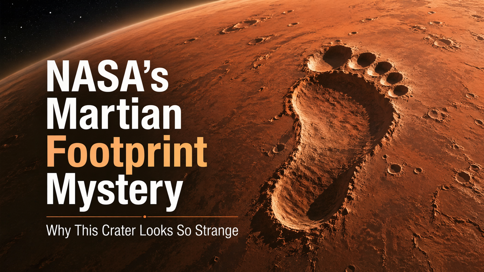
An image of a crater on Mars that many people said looked like a giant footprint pressed into the surface. The image was captured by NASA’s Mars Reconnaissance Orbiter using its powerful HiRISE camera system. (NASA Science)
At first glance, the image does look mysterious. But the truth is even more interesting than the illusion. This “footprint” is not evidence of alien life or a giant step on the Martian surface. It is a scientifically important crater called Airy-0, a feature historically used to define zero longitude on Mars, much like Greenwich helps define longitude on Earth. (NASA Jet Propulsion Laboratory (JPL))
1. Understanding NASA’s Martian Footprint Mystery
What Is the Martian Footprint Mystery?
The Martian footprint mystery refers to a NASA released image of a crater on Mars that visually resembles the outline of a footprint. The image drew attention because of its shape, shadows, and the way the surrounding terrain frames the crater. NASA’s description, however, explains that the crater is scientifically important because it marks the location of Mars’ zero longitude reference area. (NASA Science)
Why Does It Look Like a Footprint?
It looks like a footprint because the human brain is very good at spotting familiar shapes in random patterns. This effect is common in astronomy and planetary science. Lighting, crater rims, shadow angles, and surrounding landforms can combine to create a recognizable shape. In this case, the crater and the terrain around it create a visual effect that many viewers interpreted as an “alien footprint.” Media reports at the time highlighted that reaction from viewers online. (www.ndtv.com)
2. Where the Image Came From
2.1 NASA’s Mars Reconnaissance Orbiter
The image came from NASA’s Mars Reconnaissance Orbiter (MRO), one of the most important spacecraft ever sent to study Mars. MRO has spent years mapping the planet, observing landforms, and helping scientists understand Martian geology, climate history, and possible landing locations for missions. NASA identifies the “footprint” image as an MRO observation. (NASA Science)
2.2 The HiRISE Camera
The image was taken by HiRISE, short for the High-Resolution Imaging Science Experiment. This camera is famous for capturing extremely detailed images of the Martian surface. NASA and the University of Arizona’s HiRISE pages both identify the crater image as a HiRISE observation. (uahirise.org)
2.3 Airy-0 and Zero Longitude on Mars
The crater in the image is called Airy-0. NASA explains that this crater defines where zero longitude is centered on Mars, similar to how the Greenwich Observatory is connected to Earth’s prime meridian. NASA also notes that Airy-0 sits inside the larger Airy Crater, and that the smaller feature became necessary as imaging improved and map precision increased. (NASA Jet Propulsion Laboratory (JPL))
3. Why This Crater Matters Scientifically
This crater is important because accurate mapping matters in planetary science. Scientists need a reliable reference point to create maps, compare observations, guide rovers, and improve navigation for future missions. Airy-0 became a practical landmark for this purpose because it allowed Mars maps to keep continuity while improving precision. NASA says that even though modern radio tracking of landers such as InSight now improves Martian longitude measurements, the system is still defined so zero longitude stays centered on this crater. (NASA Science)
So the image is not just visually interesting. It is also connected to the way scientists organize and understand the geography of an entire planet. (NASA Science)
4. What People Get Wrong About the Image
One common misunderstanding is that the feature is artificial or somehow linked to alien activity. There is no evidence for that. NASA’s explanation is straightforward: this is a crater used in Mars cartography, not an artificial object or a trace left by a living being. (NASA Science)
Another misunderstanding is that the footprint-like shape means the whole feature is unusual by Martian standards. In reality, Mars is full of formations that look familiar to humans when seen from orbit. The unusual part here is not that Mars created a weird-looking shape, but that the shape also happens to be an important geographic reference point. (NASA Science)
5. Mars, Optical Illusions, and Human Imagination
Mars has a long history of triggering imagination. People have seen faces, animals, symbols, and strange patterns in images of its surface. This happens because our brains naturally search for meaning and familiar forms. The Martian footprint mystery is a good example of how science images can become viral while still teaching something real and valuable. In this case, an image people first saw as mysterious turned out to be a lesson in planetary mapping. (NASA Science)
6. What This Discovery Teaches Us About Planetary Science
6.1 Surface Mapping
The image shows that mapping another planet is not just about taking beautiful pictures. It is about creating precise reference systems. Without such systems, comparing mission data across years and spacecraft would be much harder. Airy-0 helps anchor Mars maps in a consistent way. (NASA Science)
6.2 Navigation and Exploration
Future exploration depends on accurate maps. Orbiters, landers, and rovers all benefit from a clear coordinate system. NASA’s materials connect Airy-0 to the broader effort of measuring and defining the Martian surface more precisely. (NASA Science)
6.3 Geological Interpretation
The image also reminds us that a crater can be both a geological feature and a cartographic reference. Scientists study its context, location, and shape not just for appearance, but for what it tells us about surface history, mapping standards, and observation techniques. (NASA Science)
7. Case Study: Why Airy-0 Is Like Greenwich on Earth
A simple way to understand Airy-0 is to compare it with Greenwich on Earth. Earth uses the prime meridian as the reference for zero longitude. Mars also needs a zero-longitude reference for its own maps. NASA directly compares Airy-0’s role on Mars to Greenwich’s role on Earth. That makes this crater much more than a viral image—it is part of the coordinate backbone of Martian cartography. (NASA Jet Propulsion Laboratory (JPL))
8. Future of Mars Imaging and Exploration
As imaging technology improves, scientists will continue refining how they observe and map Mars. High-resolution imagery, lander tracking, and future missions will make Mars maps even more accurate. NASA’s ongoing Mars science work shows that detailed imaging remains central to understanding the planet’s terrain, history, and exploration potential. (NASA Science)
This means that even images that go viral for their appearance can still contribute to serious scientific work. That is one of the most exciting parts of modern space science.
9. Beginner-Friendly Steps to Understand Mars Images Better
1. Look at the official NASA caption first.
It often explains what the image actually shows before online speculation begins. (NASA Science)
2. Check which spacecraft captured the image.
In this case, it was NASA’s Mars Reconnaissance Orbiter with the HiRISE camera. (uahirise.org)
3. Learn the scientific purpose of the feature.
Airy-0 matters because it is tied to Mars longitude, not because it resembles a footprint. (NASA Science)
4. Be careful with viral interpretations.
Interesting shapes do not automatically mean extraordinary explanations. (www.ndtv.com)
5. Use mystery as a starting point for science.
The best response to a strange image is curiosity followed by evidence.
10. Conclusion
NASA’s Martian footprint mystery is a perfect example of how a dramatic image can capture public attention while also teaching real science. What looks like a giant footprint on Mars is actually Airy-0, a crater closely linked to the definition of zero longitude on the Red Planet. Captured by NASA’s Mars Reconnaissance Orbiter through the HiRISE camera, the image is both visually fascinating and scientifically meaningful. (uahirise.org)
For beginners, this story is a reminder that planetary science is full of moments where mystery and measurement meet. Mars may look strange, but behind the strange shapes are real systems, real data, and real discoveries that help us understand another world better. (NASA Science)
11. Frequently Asked Questions (FAQ)
Is NASA’s Martian footprint mystery a real footprint?
No, it is not a real footprint. The image shows a natural crater on Mars called Airy-0. It only looks like a footprint because of its shape, lighting, and surrounding terrain.
Why does the crater look like a footprint?
It looks like a footprint because the human brain naturally recognizes familiar shapes in random patterns. This is a common effect when people look at clouds, rocks, or planetary images.
What is Airy-0 on Mars?
Airy-0 is a small crater on Mars that is important in planetary mapping. It is used as the reference point for zero longitude on Mars, similar to how Greenwich is used on Earth.
Which NASA mission captured the Martian footprint image?
The image was captured by NASA’s Mars Reconnaissance Orbiter (MRO) using the HiRISE camera, which is known for taking highly detailed images of the Martian surface.
Does this image prove alien life on Mars?
No, this image does not prove alien life. It is a natural geological feature, not an artificial structure or sign of extraterrestrial activity.
Why is this crater scientifically important?
This crater is important because it helps scientists create accurate maps of Mars. It plays a role in navigation, surface study, and future mission planning.
Is the Martian footprint mystery just an optical illusion?
Yes, in visual terms it is an optical illusion. The crater is real, but the “footprint” appearance is simply how our eyes and brain interpret the shape.
Can Mars images often look like human or animal shapes?
Yes, this happens often. Mars has many landforms that can look like faces, animals, symbols, or other familiar shapes. This is due to natural terrain patterns and lighting effects.
How can beginners understand Mars images better?
Beginners should always check:
- the official NASA caption
- the spacecraft or camera used
- the scientific explanation of the image
- whether the image is being misinterpreted online
What does this mystery teach us about Mars exploration?
It teaches us that even strange-looking images can have real scientific value. A viral image may look mysterious, but it can still help scientists better understand Mars and improve planetary mapping.