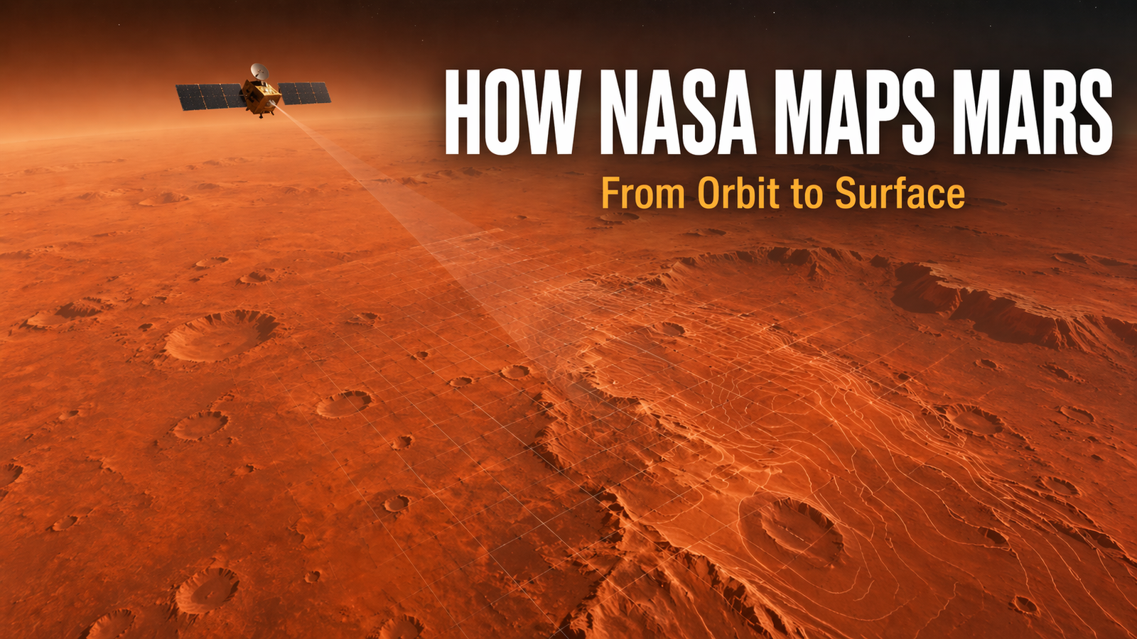
Mars may look like a dusty red world from a distance, but to scientists, it is a planet full of valleys, craters, volcanoes, canyons, dunes, and layered rock formations. To study all of this properly, NASA has to do much more than simply take pictures. It has to build accurate maps of the Martian surface using orbiters, cameras, laser measurements, and digital tools. NASA’s modern Mars mapping work relies heavily on missions such as the Mars Reconnaissance Orbiter and earlier global mapping missions like Mars Global Surveyor.
These maps are important because they help scientists study the planet, compare different regions, choose landing sites, understand elevation, and support future missions. In simple words, NASA maps Mars by combining images, height data, and surface analysis into one organized planetary picture.
1. Understanding How NASA Maps the Surface of Mars
What Does It Mean to Map Mars?
Mapping Mars means creating detailed visual and scientific representations of the planet’s surface. These maps can show surface shape, elevation, temperature patterns, terrain texture, and the location of important features such as craters, channels, and mountains. NASA does this from orbit because spacecraft circling Mars can observe huge parts of the planet repeatedly over time.
Why Mapping Mars Matters
Mapping matters because scientists cannot understand a planet well without knowing where things are, how high or low they are, and how different regions connect to one another. Accurate maps help NASA study Martian geology, search for signs of ancient water, identify safe landing zones, and guide future robotic and possibly human exploration. NASA says Mars Global Surveyor was a global mapping mission, and NASA’s Mars Trek tool shows how mapping data is also used for exploration and analysis.
2. The Main Spacecraft and Tools NASA Uses
2.1 Mars Reconnaissance Orbiter (MRO)
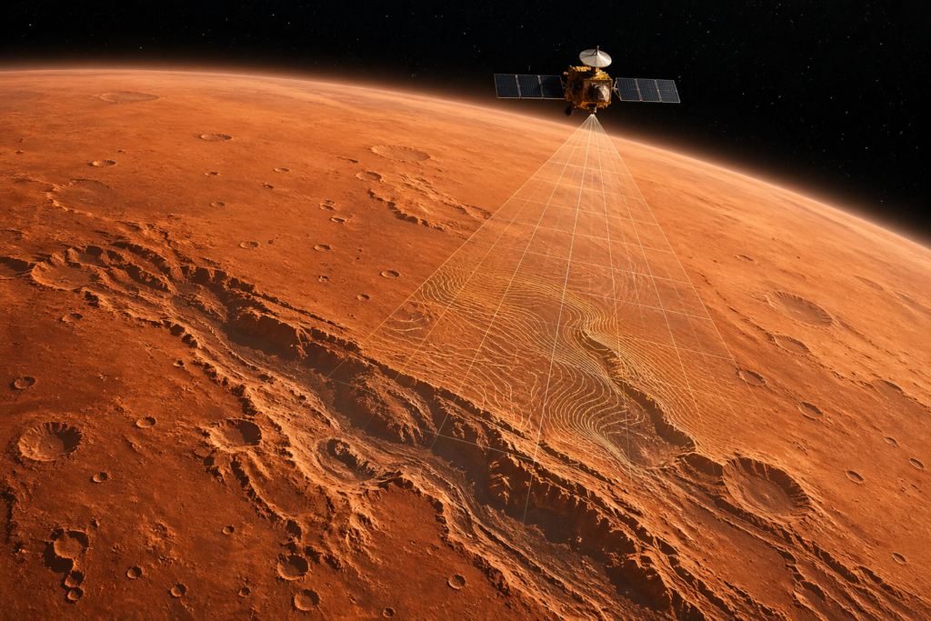
One of NASA’s most important mapping missions is the Mars Reconnaissance Orbiter. It carries several instruments that help scientists study the Martian surface in great detail. NASA’s MRO science instruments page highlights its role in observing terrain, layers, and surface features at multiple scales.
2.2 HiRISE Camera
The High Resolution Imaging Science Experiment (HiRISE) is one of the most famous cameras ever sent to Mars. NASA describes it as a powerful camera capable of imaging large areas while also seeing features as small as a kitchen table. That level of detail makes it extremely useful for close-up mapping, terrain analysis, and studying specific sites.
2.3 Context Camera (CTX)
NASA also uses the Context Camera (CTX) on MRO. While HiRISE gives extremely detailed close views, CTX gives wider-area views that help scientists understand the surrounding region. In simple terms, CTX provides the “big picture,” while HiRISE zooms in on key places. That combination is very useful when building layered maps of Mars.
2.4 Mars Global Surveyor and MOLA
Before MRO, Mars Global Surveyor played a major role in mapping the entire planet. NASA says it was a global mapping mission that examined Mars from the atmosphere to the surface. One of its most important instruments was MOLA, the Mars Orbiter Laser Altimeter. MOLA sent laser pulses toward the planet and measured the return time to determine the height of surface features. That helped create one of the most accurate topographic maps of Mars ever made.
2.5 THEMIS and Other Mapping Systems
NASA also uses data from systems such as THEMIS on Mars Odyssey. THEMIS image maps and webmaps show image footprints across Mars, helping researchers organize and compare surface observations over time. These broader image collections support planetary mapping and surface interpretation.
3. How NASA Actually Builds Maps of Mars
3.1 Taking Surface Images
The first step is collecting images from orbit. Cameras such as HiRISE and CTX photograph the Martian surface from above. Some images focus on tiny details, while others show broader landscapes. By gathering many overlapping images, scientists can cover large regions and monitor changes over time.
3.2 Measuring Height and Topography
A flat photo is useful, but NASA also needs to know height and depth. That is where topographic mapping comes in. MOLA was especially important because it measured surface elevation using laser altimetry. This allowed scientists to determine the heights of volcanoes, the depths of craters, and the slopes of valleys and plains.
3.3 Combining Data into Global Maps
After collecting imagery and elevation data, scientists combine them into larger mapping products. That means one Mars map may include visible imagery, topographic data, and image footprints from different spacecraft. NASA’s Mars Trek platform is an example of how this combined mapping information can be viewed and analyzed in one place.
3.4 Updating Maps for Missions and Research
Mars maps are not made once and then forgotten. NASA keeps updating them as new missions collect better data. New images can improve older maps, help refine landing-site analysis, and give scientists more accurate ways to study local terrain. This is why Mars mapping is an ongoing process rather than a one-time project.
4. Why NASA Uses Different Types of Mars Maps
NASA does not use only one kind of map. Different goals require different types of mapping. A visible image map helps scientists see craters and channels. A topographic map shows high and low areas. An image-footprint map helps track which parts of the planet have already been observed. Interactive tools like Mars Trek make it easier to view multiple data layers together.
This is similar to Earth, where we use road maps, satellite maps, and terrain maps for different purposes. Mars needs the same idea, just with more advanced planetary science tools.
5. How Mars Mapping Helps Rovers and Landers
Mars mapping is not only for science papers. It also helps NASA choose and support missions on the ground. NASA says Mars Global Surveyor helped identify potential landing sites for later missions and also supported rover and lander work. Detailed surface maps help engineers evaluate terrain safety, slopes, obstacles, and the scientific value of different regions.
In practical terms, good mapping helps NASA answer questions like:
- Is the surface too rough for landing?
- Are there steep slopes nearby?
- Is the site scientifically interesting?
- Can a rover move safely through the region?
Without accurate mapping, sending a rover to Mars would be much more risky.
6. Case Study: From Orbit Images to Surface Exploration
A good way to understand NASA’s mapping process is to think in layers. First, a spacecraft sees Mars from orbit. Then wide-area instruments identify interesting regions. After that, higher-resolution cameras zoom in. Elevation data adds height information. Finally, all of this is combined to help scientists study the region or prepare for future missions. NASA’s Mars mapping missions and instrument systems are designed exactly for this kind of multi-step understanding.
This layered approach is one reason NASA can move from a broad global picture to highly detailed local analysis.
7. Mars Trek: How the Public Can Explore Mars Maps Too
One interesting fact is that Mars mapping is not only for scientists. NASA offers Mars Trek, an interactive mapping application that allows users to view imagery and perform analysis on Mars data. That means students, educators, and curious readers can explore the planet through a real NASA tool.
This makes planetary mapping easier to understand because people can see how imagery, location, and analysis come together on an actual digital Mars map.
8. Future of Mars Surface Mapping
Mars mapping will likely become even more advanced in the future. Better cameras, new orbiters, improved digital terrain models, and richer data integration will help scientists study Mars with even greater precision. Current and future work builds on the huge foundation laid by missions such as Mars Global Surveyor, Mars Odyssey, and Mars Reconnaissance Orbiter.
As Mars exploration continues, accurate mapping will remain essential for both discovery and mission planning.
9. Beginner-Friendly Steps to Understand Mars Maps Better
1. Start with the basic idea.
Remember that Mars maps are made from orbit, not by someone standing on the planet.
2. Learn the difference between image maps and topographic maps.
Image maps show what the surface looks like. Topographic maps show height and depth.
3. Know the key NASA tools.
The most important names to remember are MRO, HiRISE, CTX, and MOLA.
4. Think in layers.
NASA often combines multiple data sources instead of using only one picture.
5. Explore Mars Trek.
It is one of the easiest ways for beginners to see how Mars mapping works in practice.
10. Frequently Asked Questions (FAQ)
How does NASA map the surface of Mars?
NASA maps Mars by using orbiters equipped with cameras and scientific instruments. These spacecraft collect surface images, elevation data, and other observations that are combined into digital maps.
What spacecraft helped map Mars globally?
One major mission was Mars Global Surveyor, which NASA describes as a global mapping mission. Later missions such as Mars Reconnaissance Orbiter added even more detailed mapping data.
What is MOLA?
MOLA stands for Mars Orbiter Laser Altimeter. It measured the height of Martian surface features by sending laser pulses toward the planet and timing their return.
What does HiRISE do?
HiRISE is a high-resolution camera on the Mars Reconnaissance Orbiter. It takes extremely detailed images of the Martian surface.
Why are Mars maps important?
Mars maps help scientists understand geology, study the surface, choose landing sites, and support rover and lander missions.
Can the public see NASA’s Mars maps?
Yes. NASA’s Mars Trek tool allows users to view imagery and perform analysis using Mars data.
11. Conclusion
NASA maps the surface of Mars by combining advanced orbiters, detailed cameras, and powerful scientific instruments. Missions like Mars Global Surveyor and Mars Reconnaissance Orbiter have helped transform Mars from a distant red dot into one of the best-mapped worlds in the solar system. With tools like HiRISE, CTX, and MOLA, NASA can study not only what Mars looks like, but also how high, deep, rough, and complex its terrain really is.
For beginners, the simplest way to remember the process is this: NASA photographs Mars, measures its shape, combines the data, and turns it into usable maps for science and exploration. That mapping work is one of the reasons Mars exploration continues to grow more accurate, more exciting, and more useful for the future.


1 thought on “How NASA Maps the Surface of Mars”